|
Michigan Department of Natural Resources Cass County (T6S, R15W, Sec. 11 to T5S, R14W, Sec. 16) Surveyed July 7, 9, 21, 1992 James L. Dexter, Jr. Environment Dowagiac Creek is a designated trout stream (second- quality, coldwater)
located in north central Cass County. This first-order stream originates
in a chain of lakes near Marcellus and flows in a southwesterly direction
to its confluence with the Dowagiac River. The watershed is predominantly agricultural. Gently rolling hills
of sandy loam surround the area. Human development and activity is
limited to a few homes along the creek, with plowed and fallow farmland,
and some wood lots in between. The amount of suitable trout water is estimated at 8.4 miles. The creek
falls about 67 feet (8 ft/mile) from its source at Bunker Lake to Lake
LaGrange (see map of Dowagiac Creek).
Stream width is relatively constant at 25 to 30 feet, with an average
depth of 1 foot. Holes deeper than 5 feet exist. Undercut banks, logs,
overhanging brush and grasses, pools, riffles, and boulders provide a
good array of available habitat. The amount of cover is rated as moderate
to abundant. Sand and silt comprise about 25-40% of the stream bottom,
with the remaining portion being gravel, cobble, and boulder. Dowagiac Creek is extremely productive; 15 orders of aquatic invertebrates
representing 42 separate species have been identified (Creal 1978). Mayflies,
caddisflies, stoneflies, and dragonflies are all common to abundant. Methyl-orange
alkalinity measurements range from 150-200 ppm. The pH averages 8.0. Dissolved
oxygen levels have always been above 5 ppm when sampled. Water temperatures
vary (57-76F), but average about 69F during summer. The water cools at
least 6F from below Bunker Lake (Goodenough Road) to the end of the managed
trout water near Lake LaGrange, as measured with continuous recording
thermometers in 1994 and 1995. The upstream areas are too warm for trout
survival, with up to a month of summer temperatures in the 75-80F range.
Daily temperature fluctuations over the course of the entire stream are
3-13F. In the lower section of river (Kelsey Lake Road, map
of Dowagiac Creek), stream temperatures during the summer of 1994
rose to 75F only twice, and usually never rose above 73F. This is due
to the large infusion of groundwater into the stream which helps keep
the lower river system quite cool. There is no State-owned land along the creek, but it does flow through
the Russ Forest, which is owned by Michigan State University. Anglers
currently have no problems obtaining landowner permission to fish most
of the creek. Historically, Dowagiac Creek has been managed for trout since at least
1933. Brown, brook, and rainbow trout have all been planted; however,
only browns have been stocked since 1964. The creek has many faithful anglers, some who have been fishing there
for decades. It is very good dry fly water, being sufficiently wide to
permit fly casting by the novice. This feature is rare in many southern
Michigan trout streams. Anglers do quite well, catching trout from 5-24
inches. Many limit catches are reported. The first survey ever conducted on Dowagiac Creek appears to have been
in 1959. Brown and rainbow trout were enumerated, "many" creek chubs and
common shiners were noted, and a "few" mottled sculpins were reported.
The next survey was not conducted until 1969, when no trout were collected
and several species of cyprinids and centrarchids dominated the
catch. This survey lead to the proposal for the first chemical reclamation
in May 1971. This treatment, and the subsequent treatment in October 1980,
achieved very favorable results and allowed for excellent trout angling.
During both treatments, fair numbers were noted of naturally produced
young-of-the-year brown trout in the lower section of the creek. An additional
10 surveys were conducted between 1970 and 1990, mostly as spot checks
following reclamation. In 1977, Fisheries Division constructed a rough fish barrier a short
distance upstream of Lake LaGrange (the lower end of the designated trout
water). This barrier (located on the old Bernard Hill property) has been
very successful and has been instrumental in allowing a longer-than-usual
period between chemical treatments. Other than incursion of other species into the system, the only other
management problem to date has been the potential failure of the dike
at the Hill property where the barrier is located. This dike dates back
to the 1800's, and was the site of at least two grist mills. One of the
grist mill's cement foundations started to erode in November of 1993,
and threatened to break the dike and render the fish barrier useless.
Repairs were made during the same month by the St. Joseph River Valley
Fly Fishers (SJRVFF), of South Bend, Indiana, at our direction. Repairs
included installment of rock riprap and gravel to shore up the structure
(pictures on file in district office). Two habitat improvement projects have also been completed, both by the
SJRVFF. In 1989, about 1 mile of the creek was improved for trout habitat
in Newton Woods of Michigan State University's Russ Forest. Work included
installation of 32 feet of lunker structures at the canoe launch near
the parking lot, opening of channel-blocking log jams, and repositioning
of this wood in the channel to benefit trout cover and scour holes (permit
#89-12-0281). In 1990, another 64 feet of lunker structures were installed
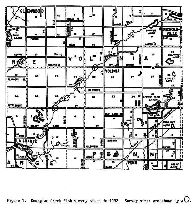
just above Griffis Road. No pre- or post-evaluation work was conducted. In 1992, a fish survey was conducted at five sites (see
map of Dowagiac Creek). It was one of the most intensive surveys ever
made on the creek. Using a 250-volt DC shocker unit with two probes, a
total of 19 species of fish were collected (Table 1). Blacknose dace,
central mudminnow, creek chub, and mottled sculpin were the most numerous
species, accounting for over 57% of the total catch by number. Brown trout
comprised 11.5% of the total catch by number. Brown trout were collected
at each survey site. The catch-per-hour rate (CPE) for trout was 41/hour,
with 17% of the catch being legal size (greater than 8 inches). Naturally produced brown trout were found at stations 1, 2, 3, and 4.
All browns collected at station 5 were determined to be of hatchery origin.
Origin was judged from size (i.e., naturally produced young-of-the-year
were 2-4") or fin characteristics. Hatchery browns are easily distinguished
by eroded fins or regenerated crooked fins. We estimated that 32% of the
brown trout catch was from natural reproduction. Growth rates of brown
trout were good, with all fish sampled growing at state average rates
(Table 2). Aging was also done on 6 of 8 largemouth bass collected. These
were also growing at state average, indicating the stream is marginally
warm for trout. The age frequency sample of brown trout (Table 3) indicated good recruitment
of age I+ fish, but a very high mortality rate following that. Based on
this survey, there are few fish left to grow to a large size. Some interesting changes occurred in the fish community between 1971
and 1992. Appendix 1 lists all species collected by number for every survey
since 1971, including number of stations and hours electroshocked. To
date, 32 species of fish have been identified in the system. Since the
last chemical reclamation in 1980, potentially three species (northern
hogsucker, golden shiner, and common stoneroller) have been extirpated.
Pirate perch and madtom are now found in limited numbers, as only one
individual of each has been collected since 1981. Brook silverside, greenside
darter, and chestnut lamprey, all enumerated in the pretreatment survey
of April 1971, were not found in recent surveys. Many of the species listed
in Appendix 1, but not found in recent surveys, could infiltrate back
in from the Bunker Lake watershed. The fish community present in 1992 is actually little changed from the
pre-reclamation period. The only significant difference from a management
perspective (other than those species extirpated) is a decline in the
number of rainbow darters seen, and an increase in the number of central
mudminnows. These changes could be due to changes in electroshocking efficiency
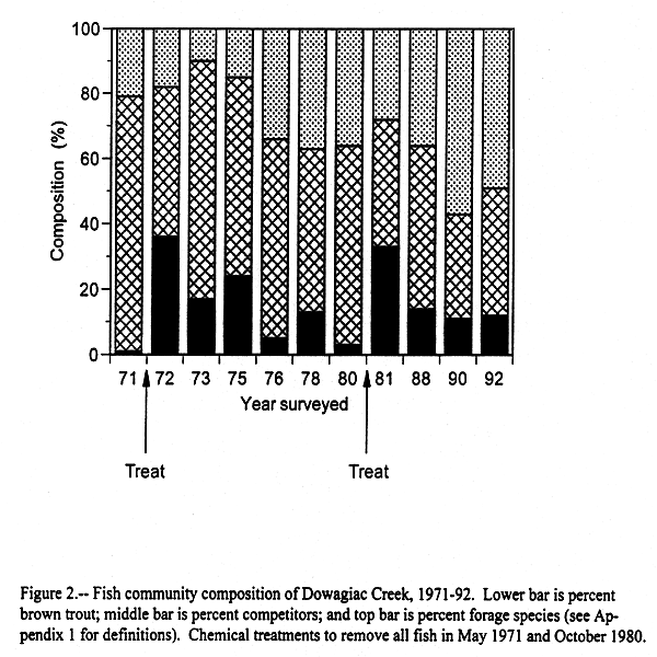
over time. Since the 1980 reclamation, brown trout CPE fell from a high of 77/hour
in 1981 to a low of 34/hour in 1990 (Appendix 1). A slight increase in
CPE to 41/hour was seen in 1992. Since 1988, the percent contribution
of brown trout to the fish community has been stable (Figure
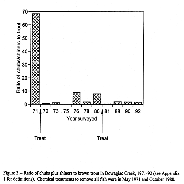
2). However, the forage species appear to be on the increase. Chubs and shiners generally seem to be the "enemy" when it comes to trout
fishing. When the numbers of these fish become excessive, anglers complain
because they usually catch more chubs and shiners that trout. I looked
at the ratio of chubs to trout (Figure 3)
and found that while numbers of these competitors were high prior to treatments,
that since 1988 the ratio has been fairly low and stable. An assumption
here, however, is that effort expended to collect these species was similar
in each survey. Dowagiac Creek compares very favorably with other southwest Michigan
trout streams. Unlike many of our marginal streams, about 1/3 of its trout
population from natural reproduction. This is similar to Augusta Creek
in Kalamazoo County, and the East Branch of the Paw Paw in Van Buren County.
Few of our marginal streams have the variety and number of insects as
Dowagiac Creek. These factors, plus the capability of the stream to produce
very large brown trout, support the conclusion that the Dowagiac is one
of the best trout streams in southwest Michigan. Dowagiac Creek should continue to be managed as a marginal trout stream.
At present, the stocking rate of brown trout is 243 yearlings per acre.
Even though I am recommending that the Goodenough Road stocking site be
deleted, I recommend these fish be used at the other stocking sites. The current high angling use of the creek will require continued planting
of trout. Natural reproduction is not enough to sustain the present level
of fishing, especially with all the other species present. The majority
of instream habitat is excellent, however, there are some areas which
lack cover. These areas may be pursued in the future for improvement by
the SJRVFF at our direction. It is hard to tell at this point when the stream may need to be reclaimed.
In 1988 I felt it was time for another treatment, but anglers were very
negative to that proposal. They remain so today. Even though competing
species appear numerous, all contacted anglers speak of the excellent
overall trout fishing. At this point I am willing to let the anglers tell
me when the stream needs reclaiming. Instead we will focus our management
on closely defining the suitable trout water by conducting more temperature
monitoring, and possibly, on designing more habitat improvement projects. In 1988, I recommended the stocking rate be reduced by 53% due to the
amount of natural reproduction. This management change has not hurt the
fishery of the creek, and may have even helped to extend the period of
no chemical reclamation by allowing the more vigorous naturally produced
trout a better chance to survive. Competing species have free access to the upper portion of Dowagiac Creek.
The rough fish barrier in the lower end of the creek has served its purpose
well by keeping other fish species out and allowing the effects of previous
treatments to last many more years than usual. In addition, in 1995 the
dam at Lake LaGrange was opened and the lake was drained to sill level.
This will further enhance the effectiveness of the fish barrier. If the
lake stays down into the future, additional river miles could become available
for trout management. Report completed February 1996. Creal, W. 1978. A macroinvertebrate survey of Dowagiac Creek and Dowagiac
River, Cass County, Michigan. August 18, 1977, Michigan Department of
Natural Resources, Surface Water Quality Division, Lansing. Table 1.- Number, weight, and length (inches) of fish collected
from five sites on Dowagiac Creek with 250-V DC streamshocker, 2 probes,
July 7, 9, and 21, 1992.
Table 2. - Average weighted total length (inches) at age, and
growth relative to the state average, for fish sampled from Dowagiac Creek
with 250-V DC streamshocker, 2 Probes, July 7, 9, & 21, 1992. Number
of fish aged is given in parentheses.
Table 3. - Estimated age frequency (percent) of fish caught from
Dowagiac Creek with 250-V DC streamshocker, 2 probes, July 7, 9, &
21, 1992.
Appendix 1.-Dowagiac Creek fish surveys, 1971-92. Chemical reclamations
in May 1971 and October 1980.
aForage fish includes: Blacknose dace, bluntnose
minnow, central stoneroller, brook silverside, madtom, johnny darter,
rainbow darter, greenside darter, mottled sculpin, central mudminnow,
and pirate perch. Cass County (T6S, R15W, Section 11 to T5S, R14W, Section 16) MANAGEMENT PLAN James L. Dexter, Jr. Our management goal for Dowagiac Creek will be to maintain the excellent
trout fishing available now without having to resort to chemical reclamation.
Three objectives will be necessary to help guide us toward this goal. Temperature data collected from June of 1994 to May of 1995 at two locations
on Dowagiac Creek (upstream and downstream) indicated that the uppermost
stocking site at Goodenough Road is not suited to trout survival. Objective
1 is to delete this site from the stocking request and redistribute those
fish to other downstream locations. Objective 2 is to obtain additional
temperature monitoring units and further refine the area of "good" trout
water. This will be done by installing units at the next site downstream
of Goodenough (Marcellus Highway) and again at Kelsey Lake Road for comparison.
Our goal is to complete this by the year 1999. Objective 3 is to resample the 1992 survey sites. This should be done
in 1998 and include a good effort to collect all fish for community composition
and comparison. This survey, along with the new temperature data, will
help us refine our management of stocked trout in the Dowagiac Creek. Plan completed: February 1996.
Last Update: 08/05/02
[email protected] |
|||||||||||||||||||||||||||||||||||||||||||||||||||||||||||||||||||||||||||||||||||||||||||||||||||||||||||||||||||||||||||||||||||||||||||||||||||||||||||||||||||||||||||||||||||||||||||||||||||||||||||||||||||||||||||||||||||||||||||||||||||||||||||||||||||||||||||||||||||||||||||||||||||||||||||||||||||||||||||||||||||||||||||||||||||||||||||||||||||||||||||||||||||||||||||||||||||||||||||||||||||||||||||||||||||||||||||||||||||||||||||||||||||||||||||||||||||||||||||||||||||||||||||||||||||||||||||||||||||||||||||||||||||||||||||||||||||||||||||||||||||||||||||||||||||||||||||||||||||||||||||||||||||||||||||||||||||||||||||||||||||||||||||||||||||||||||||||||||||||||||||||||||||||||||||||||||||||||||||||||||||||||||||||||||||||||||||||||||||||||||||||||||||||||||||||||||||||||||||||||||||||||||||||||||||||||||||||||||||||||||||||||||||||||||||||||||||||||||||||||||||||||||||||||||||||||||||||||||||||||||||||||||||||||||||||||||||||||||||||||||||||||||||||||||||||||||||||||||||||||