Property Information
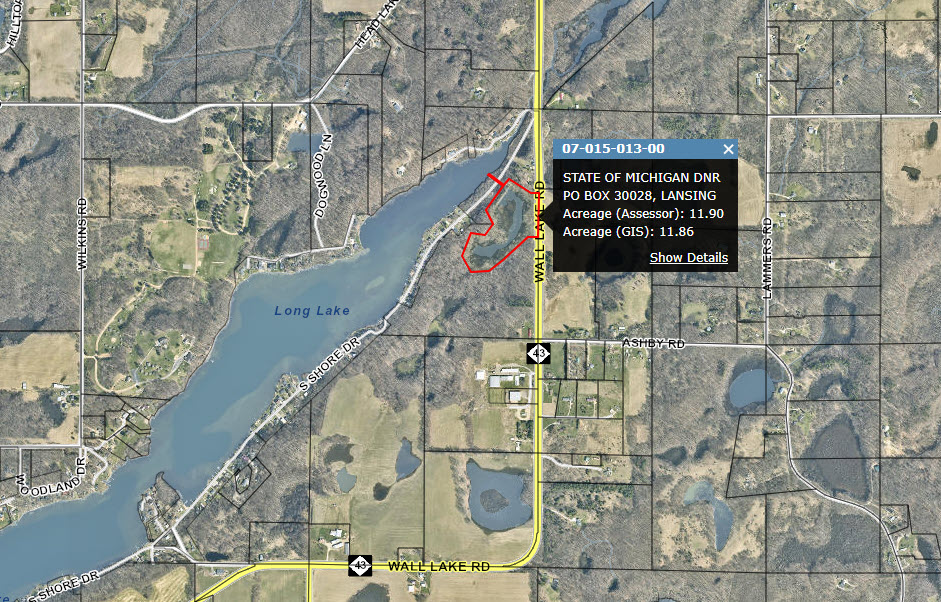
- Parcel Number
- 4214, 4215
- County
- Barry
- Size:
- 12.00 acres
- Minimum Accepted
- $63,000.00
- Tax Parcel #
- 07-015-013-00
- Description
-
Barry, T02N, R09W, S15
Part of the SE ¼ of NW ¼, beginning at a point at NE corner of said SE ¼ of NW ¼ which is 1,314.67 feet South of the North ¼ corner of Section 15, thence N89D40’W 523.18 feet along a fence line on North line of said SE ¼ of NW ¼ to an iron marker, thence S33D30’W 170.42 feet, thence N79D30’30”W 165.50 feet, thence S19D45’30”E 204.5 feet, thence N86D45’E 215.4 feet, thence N49D24’E 201.2 feet, thence N47D41’E 393.16 feet, thence N88D21’E 120.7 feet to North-South ¼ line of Section 15, thence North along said ¼ line 150 feet to POB, containing 6.7 acres more or less, ALSO Part of the NE ¼ of NW ¼, beginning at a point at SE corner of said NE ¼ of NW ¼, which is 1,314.67 feet South of the North ¼ corner of Section 15, thence N89D40’W 523.18 feet along a fence line on South line of said NE ¼ of NW ¼ to an iron marker, thence N28D15’W 172.9 feet, thence N35D51’E 336.95 feet to Point A, thence N54D09’W about 150 feet to shore of Long Lake, being Couse B, thence Northeasterly along lake 20 feet more or less, thence S54D09’E along a course 20 feet distant from and parallel to Course B a distance of 150 feet more or less to a point which is N35D51’E 20 feet from Point A, thence North 35D51’E 80 feet, thence S58D09’E 302.32 feet, thence N90D00’E 94.3 feet to North-South ¼ line of Section 15, thence South along said ¼ line 350 feet to POB, containing 5.3 acres more or less.
- Comments
- The subject property is an irregular shaped vacant 12-acre parcel that is adjacent to 2 private landowners. The road frontage on M43 has a guardrail lining the side of the road, potentially preventing the installation of a driveway. The property also has approximately 20 feet of frontage on Long Lake. Most of the property is composed of poorly drained & ponded muck soils with 0 to 1% slopes and well drained sandy loam soils with 6 to 12% slopes near M43. The parcel is zoned within the AR Agricultural/Residential District, which requires 1 acre, with 50 foot of road frontage, and a minimum lot width of 200 foot to meet local zoning to build requirements. The subject property does meet local zoning to build as standalone parcel based on the local zoning ordinance but would likely require fill to be brought in and the M43 guardrail cut. Interested buyers should contact Hope Township if interested in building on the property and the Barry County Road Commission for questions about the guardrail. Contact: Mike Michalek at (517)331-8387 or by email [email protected].
- Location
- The parcel is located on M43 and S Shore Drive, south of their intersection, about 9 miles southwest of Hastings, MI.
- Parcel Status:
- Available
- Frontage and Access
- Road Frontage
- Cover
- Forested
- Utilities
- Electric
- Reservations
- A property right in aboriginal antiquities including mounds, earthworks, forts, burial and village sites, mines, or other relics and also reserving the right to explore and excavate for the same as provided under Article III, part 761 of PA 451 of 1994 as amended
- Disclaimer
- - These properties are subject to applicable state, county or local zoning or building ordinances. - The State of Michigan does not guarantee the usability or access to any of these lands. - It is the responsibility of prospective purchasers to do their own research as to the use of the land for their intended purpose and to make a personal inspection of the property to determine if it will be suitable for the purposes for which it is being purchased. Purchasers are advised to consult the local zoning administrator if necessary. - The State of Michigan makes no representations or claims as to fitness for purpose, ingress/egress, conditions, covenants, or restrictions. - The properties are sold by their LEGAL DESCRIPTION ONLY. (Subdivision name and Lot number, or measured Metes and Bounds, or standard fractions of a Section, or Government Land Office Survey description). - While effort is made to ensure that the addresses, maps, and/or photos on the website are accurate, you are relying on your own investigation and information when purchasing this property. PLEASE DO YOUR RESEARCH THOROUGHLY AND CAREFULLY. - All parcels are sold as is where is and there are NO REFUNDS.
Please download the form from the following link, print it, fill the details and mail it to the address indicated on the form. Purchase Form